My wife and I organised a fellowship weekend away in Castleton, which for the uninitiated is a beautiful little town in the English Peak District. We brought along a group from our ecclesia, including quite a few children under 10, leaving us with the interesting problem of organising a Bible-based activity for them all.
We came up with the idea of using the hall floor space to create a massive map of Israel. There are several reasons why this is a useful exercise:
- While reading the Bible we often come across place names without a real context of where they are. When Jesus walked around Galilee, was it that far? How far was it from Galilee to Jerusalem?
- God used the geography of the land to teach Israel important spiritual lessons which can be lost on us if we don’t understand the land itself: “[Israel] is not like Egypt…it drinks rain from heaven” (Deut 11v10-12)
- These questions are doubly important for children, for whom things can be even more confusing. Is Jezreel a city, or a valley?
Here’s how we did it. First, a list of ingredients:
- Lots of electrical or duct tape, in as many colours as possible.
- Coloured paper and card
- Felt tip pens
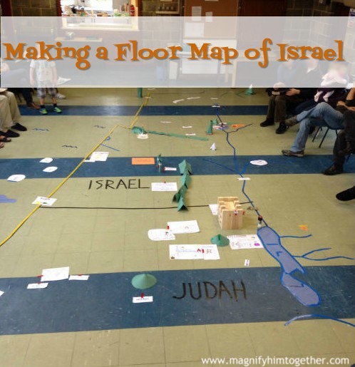
The first step was to clear the floor space and mark out the coastline of Israel. I didn’t explain to the participants beforehand what the activity would be, so sticking down the black coast tape generated quite a bit of interest while people figured out what the line represented.
After this it was all down to the group: I briefly explained that I wanted them to open their Bibles to the map section at the back and start to fill in the detail. I invited a few people to take on co-ordination of particular tasks: river systems (blue tape), mountains and hills (green tape), and cities (red tape), but left everyone else to self-organise.
Here’s what we ended up with.

Israel (above) – I’m quite grateful that someone outlined the coast in yellow because it probably wouldn’t show up on the picture so well otherwise.

Dead sea (above) – The Mount of Olives is not quite in the place because an enterprising participant actually made one that split in two, and it didn’t quite get assembled again in the right place. The precarious structure is appropriately Jericho, made of giant Jenga bricks.

Jezreel valley (above) – Looking east from the Mediterranean up the Jezreel valley. The mountain builders were busy here: that’s Carmel with Elijah’s contest in the foreground, with Mt Tabor and Galilee in the distance.

The North (above) – Looking toward Galilee along the Jordan river. Mt Tabor is shown again, along with several cities around the edge of the lake. The snow-capped peaks of Mt. Hermon in the top right are further handiwork of mountain builders .
I was quite pleased with the result, but more so with a process that managed to get young and old working together with their Bibles open. Each city was accompanied by pictures of what happened there, helping to associate the locations with Bible events, characters and stories.
Reprinted with permission from here.